- Thumbnail
- Resource ID
- 7be8acac-6f6a-11e9-8d7d-000d3ab6a624
- Title
- TV_JAM_JAMAICA-Bottom West
- Date
- May 5, 2019, 2:17 p.m., Publication
- Abstract
- The Data was created under the Jamaican Coastal Project in 1997. The output of the project, A Coastal Atlas of Jamaica, was prepared by the Natural Resources Conservation Authority (NRCA) and Uppsala University, Sweden.
- Edition
- --
- Owner
- gridanode
- Point of Contact
- devrsgis@gmail.com
- Purpose
- --
- Maintenance Frequency
- None
- Type
- not filled
- Restrictions
- None
- None
- License
- None
- Language
- eng
- Temporal Extent
- Start
- --
- End
- --
- Supplemental Information
- No information provided
- Data Quality
- --
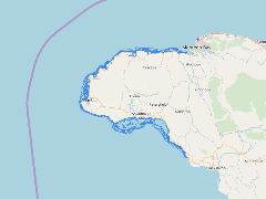
- Extent
-
- long min: -78.3759230300
- long max: -77.9586139461
- lat min: 18.0645969714
- lat max: 18.4727861614
- Spatial Reference System Identifier
- EPSG:900913
- Keywords
- no keywords
- Category
- None